Υψηλά και χαμηλά νέφη, νεφόστρωμα, ομίχλη
5 Σεπτεμβρίου 1999 13:45 UTC
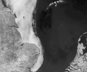
Νότια Βόρεια Θάλασσα. Στην ορατή εικόνα μια λωρίδα από σύννεφα (1) εμφανίζεται κατά μήκος της Αγγλίας. Ο ουρανός είναι γενικά καθαρός πάνω από τη θάλασσα, εκτός από ένα μικρό σχηματισμό σύννεφων (2). Στην υπέρυθρη απεικόνιση η λωρίδα των σύννεφων (3) κατά μήκος της Αγγλίας δεν είναι τόσο ορατή. Εμφανίζεται λίγο πιο αχνή από τη θάλασσα. Η θερμοκρασία στην κορυφή αυτών των νεφών δεν είναι πολύ πιο χαμηλή από τη θερμοκρασία της θάλασσας. Αυτό σημαίνει ότι πρόκειται μάλλον για χαμηλά νέφη ή ακόμη και ομίχλη. Από την άλλη πλευρά, ο μικρός σχηματισμός νεφών (4) εμφανίζεται εμφανώς πιο λευκός από τη θάλασσα, μιας και πρόκειται για σύννεφα σε μεγάλο ύψος.
Ορατή εικόνα

Υπέρυθρη εικόνα